Friday 13 March 2015

Catalina Highway to Mount Lemmon AZ


7 March 2015    Hoodoo You Love….

From Windy Point looking south.
Sometimes getting into the car and driving for 30 miles ends up at Costco. The biggest drama is at the till – as in will we be under or over 400 bucks this time? Rarely do we get the chance to leave home and drive up over 8,000 feet of elevation in an hour (8,237’ to be exact but then who was counting?).

Just coming off the desert floor.
Seems this is the perfect environment for these guys.
The hills are thick with saguaros.
The Catalina takes you into the Coronado Forest which varies from densely packed Saguaros near the desert floor all the way up to familiar conifers. It’s likened to driving from Mexico to Canada. We’ve done both and this trip did not cause my butt to fall asleep 12 times so I think I like it best.


We're going to the top of the left side.


Not an illusion - that outcrop is over the roadway

Norene was very well behaved on the trip so she was allowed to go rock climbing at Windy Point – about ½ way up the hill (in elevation). This is what she looked like approaching the end of the Point:


And at the end:


And this is what she saw when she turned around:

There is a climber setting up on the top of that table rock.
You will be traveling pretty slow on this highway (35 mph limit). Or you could go real fast, miss a corner and discover what “terminal velocity” feels like for a few seconds.
The Highway is littered with climbing cyclists – we were both terribly unhappy that our collapsible bikes appear clearly unsuited to this task. We did have a plan that would allow one of us to ride down but it failed since we couldn’t agree on who would be driving the car back.

More hoodoos
At 7,000' conifers reign.
Near the top - no snow so far.
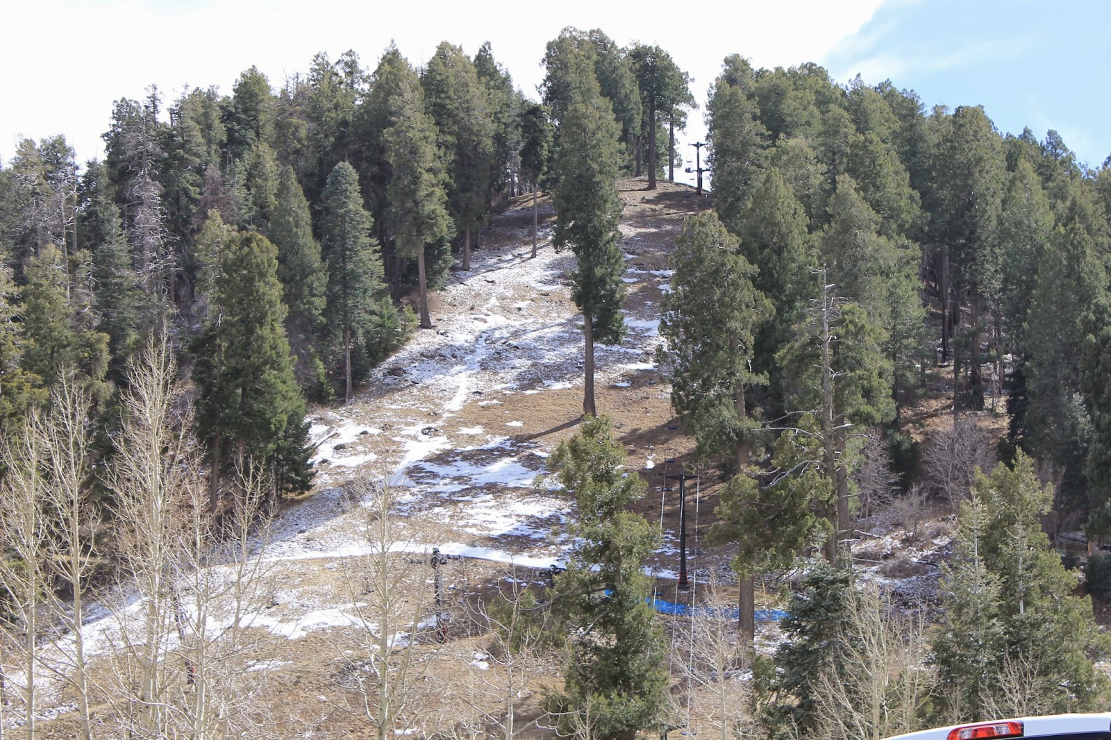
And no more driving, sledding, snow play, outlet, parking or elevation gain
Idiot flatlanders do not check weather conditions at the top of Mount Lemmon – they just hop in the car and note that Smiley has 4 wheel drive. Fortunately for us the mountaintop is missing about 12’ of snow this year. Not good for skiers (this is the most southerly ski destination in the continental US). Summerhaven – a little village near the summit appeared virtually deserted.


Most of the campgrounds were closed in spite of the temps in the 70’s at 8000’. Had to check our watches (that little date window thingie) and remind ourselves this was not an Ontario summer – still the dead of winter in most parts.


This was fun (yes kids – old people still have fun even if we're can't text while driving) and a great way to make a short trip really count. Cheaper than Costco (actually no charge) and less tiring that traveling 1500 miles from Canada to Mexico. And absolutely no part of your body will fall asleep on a highway full of hairpin turns and terminal velocity opportunities.

Looking down on Tuscon in the valley


Wednesday 11 March 2015

Salvation Mountain Niland California


9 February 2015 Artistic License rules at The Slabs


A long time ago the military abandoned a WWII base just a bit east of Niland California. Took away all the buildings but left the slab bases. Hence the name Slab City or The Slabs. Not hard to find – Niland is on Highway 111 along the lower east edge of the Salton Sea.
Since they didn’t know what to do with this dry infertile chunk of desert, and they lived on the east coast, the Federal government gave the land to California in 1961. California doesn’t know what to do with it so it allows free camping anywhere in the area. No services and no regulation. Brings out individualistic folks with an unfettered take on art, architecture, and living standards. And Norene thought I might be harsh - see how PC I can be?
A primary draw is Salvation Mountain:

Read about this years ago. Just as weird as I expected.
Yes - there is an interior.

In here.
Feeling cozy?


If you have to ask go back and read your bible again.
Now you know what happened to your Aunt's Pinto.
And here’s the back story:


We drove around the area a bit just to get the flavour. It is a community in the best voluntary sense but with a clear desire to keep a respectful distance from each other. Sometimes the messages are amusing:

Actually I understood by the presence of the truck, trailer, tent, tchotskies, fence, and dogs that the site is "Occupied" but thanks for the notice

Nice tropical look.

And sometimes a bit obscure:

There isn't a real river for many miles from here. It's OK to dream.
I did not come away with a burning desire to build a mud and latex paint church. And though I think it’s a great idea that even the least artistic among us deserve the opportunity to express themselves I have an unexpected newfound appreciation for building permits and architectural controls.

Monday 2 March 2015

Telegraph Pass (Signal Hill) Yuma AZ


24 February 2015 A bit late for a Rite of Passage but WE DID IT!

Bottom of the service road
We’d been working up to this one. Tom Nunn’s Yuma Hikes I book describes this hike as “moderate but a serious workout”. Everyone we talk to about hiking around here asks if we have “done” Signal Hill. Even if they haven’t. It’s that famous.

Jeep road approach
It’s really quite simple. Start walking up a narrow concrete service road after a short desert trail or jeep road (there are 2 approaches) until you get to the top. The only hard part is that this is a STEEP continuous hill with NO FLAT SPOTS. The grade appears to be about 20% and feels like 40%. Even the young whippersnappers who clipped by us on one stretch had to stop to catch their breath 30 yards up. Some don’t make it all the way. Some do it 3 times a week (freaks).

Tom says this is a 2 mile hike with an elevation gain of 800 feet. Took us 3 hours round trip with some short stops on the way up to rebuild O2 levels, plus camera time at the top and a signing of the hiker’s book. Going down was almost as much fun since whole new muscle teams were working to keep us off our faces.

Took pictures to impress you. Maybe even to convey how steep this is. Hope it gets you itching to do this hike so we can share pain stories.

Feeling our age (96) at this point


So been there done that. Now that we’ve “done” Signal Hill we can start heading east. 

Totally relaxed hikers trying not to look like they're leaning on their sticks.
Come back in a few days and I’ll have a few pictures of Salvation Mountain in California adorning this blog.

Next stop Tucson.


Pilot Knob California


15 February 2015                      Another nice little walk gone all to hell

The notch in the middle is our goal. It is a steep rocky path
OK maybe not “all to hell”. But after 4½ hours divided into climbing and circling Pilot Knob all the fresh dewiness was baked out of us by the desert sun (in the low 80’s by 2 pm). 

Pilot Knob is a little piece of the Cargo Muchacho Mountain range a few miles west of Yuma. Rises up from the desert plain about 600’ but we decided to climb the western notch (only about 400’) and then circumnavigate The Knob.

Looking northwest from The Notch.
That's Mexican garbage burning just south of the border fence (thin brown line).
This is the path up and down. Fortunately the folks we met on the top had already tossed the rattlesnake they found on the path off to the side.
Famous local explorer. Not a snake lover.
The range from the south.
The usual – just follow the trails that eventually disappear then make your own. Figured we moved at about 2 miles an hour since a lot was up and down through the usual washes.
 
This will not stay flat - a down and up are on the way (many many times)
 
 
Nothing really steep. You will not go far south (Mexico) or east (All American Canal).

Lunch. Standing. Hot. Canal is well guarded by thorny things.
All we have to do is get up this hill after lunch and we'll be homeward bound (idiots).
Once you reach the Canal you are past the logical point of no return and might as well continue on to complete the circle. Better than accepting the defeat of retracing your steps. I’m not saying we had any false trail starts, just that we got to enjoy a few places more than once. Not all are treasured memories.
Naturally we got along smoothly – no reason for heat, pain or tiredness to cause friction –we’re too mature for that.

Plucky hiker with Quechan Casino behind him. All American Canal heading northeast.
View of north side. Homeward bound.
Just a few more up and downs. And false starts.
After climbing back out of the last of the many washes we could see Smiley far in the distance and wondered to ourselves why we parked it so damn far away.

Last trail up to the flat plain.
Another shot of The Notch on the way to our car.

Summary of this one? If you are feeling a little too perky and need a bit of punishment do the walk around The Knob (we figure we hiked between 8 and 9 miles).  Your reward will be an end to the punishment when you finish unlike many hikes where you get to see incredible natural sights and fabulous flora. And you get to brag you did it.

Did somebody snicker?